In this article, we continue our series on good quality urban design focusing on understanding connectivity to local services for new developments. Recently, we’ve also shared an article about the importance of trees in new development planning, the benefits for wellbeing of residents, and the project owners' business case. You can find more about this article here.
Understanding connectivity fast and easily enables you to develop suitable solutions, plan ahead for consultations, and to network with local decision makers around those issues. A problem well understood, is a problem half solved!
For this article, we will using the PlaceChangers Site Insights tool applied to a residential development site for about 150 homes near Durham. We will rapidly analyse this residential site for coverage for key local amenities and community facilities based on different walking distances, as recently suggested by Esther Kurtland (UDL).
Whether you are a land manager looking for development opportunities or a local planner trying to understand improvements to a local area or district — with walking-distance-based coverage analysis, you can assess the suitability of sites easily.
Connectivity in suburbia
At PlaceChangers, we are advocates of the 20-minute neighbourhood principles developed in Melbourne. The logic is compelling. Short distances promote active travel and research shows that such environmentally-responsive design supports healthy lives. Critiques highly say that the 20-minute neighbourhood principle works particularly well in denser city environments. The reality is that much of new housing comes forward in urban fringe locations. Housing sites in suburban or rural locations often finds it more challenging to plan for walking distance access to key local amenities.
In England, 91% of the 803,000 homes built between 2011 and 2019 were built in the suburbs. The majority of new homes emerge at edge-of-town locations, where local facilities are further apart and mobility networks are less dense than in cities. While at first glance this looks like a major obstacle, it is a massive opportunity for improved planning of infrastructure and amenity provision in anticipation of producing quality neighbourhoods.
In terms of what influences travel behaviour, the good news is that density is not a major factor. Walking distances to neighbourhood facilities is the key factor to influence mode choice. 90% of trips under 400 metres were by foot; which reduces to 37% when the walking distance increases to 15minutes. Research shows that permeable road networks support ease of movement. However, not to be forgotten are also the positive cultural attitudes towards active travelling. This is what can be observed in Cambridge, where active travel distances are above average for the nation.
Analysing sites for connectivity
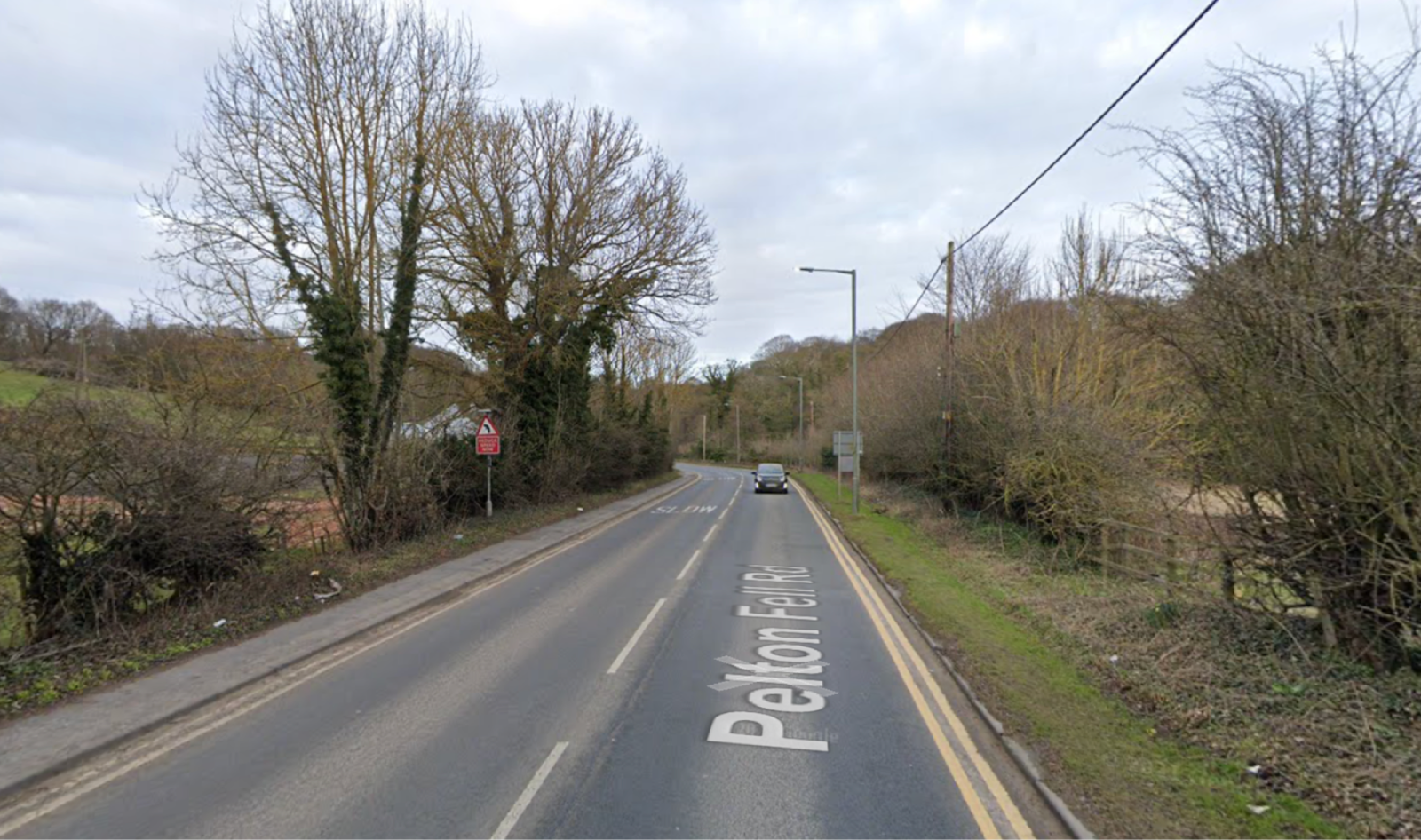
Let’s look at an example of a suburban housing project for a 150-homes project in Pelton, which PlaceChangers was engaged to support through its digital platform. Pelton is a small suburb of Chester-Le-Street on the East coast main line. Pelton largely comprises lower density residential areas. The population in 2011 was about 8,250 that largely live in patches constructed over the years.
The 'home zones' (1-minute walk)
‘Home zones’ consist of low-speed residential streets designed on a concept of ‘shared space’, balancing the needs of pedestrians and vehicular traffic surrounding a person’s home. Looking at developments nearby, the area generally does not feature significant shared spaces in nearby residential areas. The developer has control of the developer through good urban design.
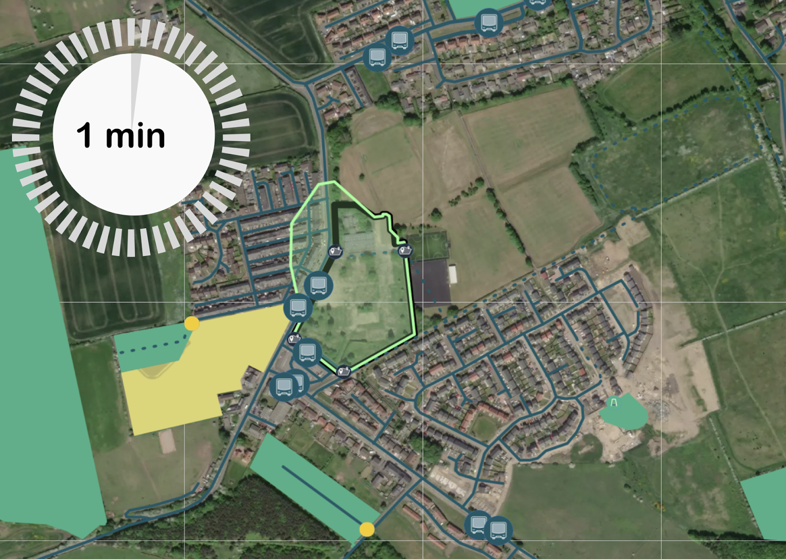
A recent study found that people perceived their environment was more pleasant after shared spaces were introduced. However, the study also found little significant “health and wellbeing benefits” that could be attributed to the availability of shared spaces if those interventions were not sufficiently significant. To achieve significant changes for health and wellbeing, requires deeper changes to the environment, such as trees and green space. Shared spaces are also strengthened if designs include active frontages and shops to invite browsing of facilities and social activities.
The immediate neighbourhood (5-minute walk)
The immediate neighbourhood drives neighbourhood satisfaction for local residents. Factors to support satisfaction include "safety and walkability, friends nearby and low traffic and noise.” Importantly, another study done in Denmark demonstrated that the presence of cycling infrastructure in the first km of residences support active travel choices.
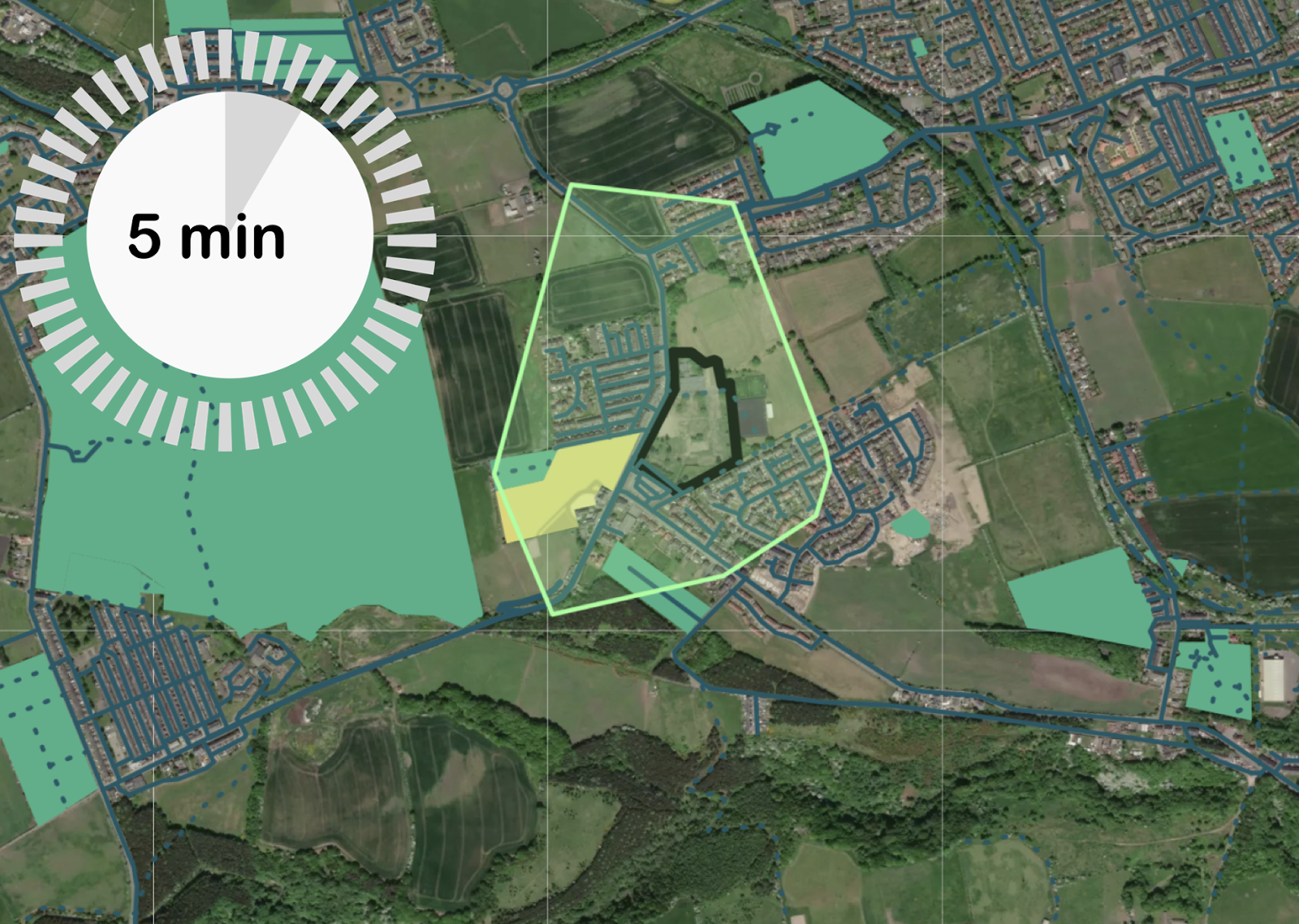
As an example of challenges in suburban locations, PlaceChangers Site Insights flags up a lack of grocery stores that would make people walk on a daily basis (coverage map below). The next grocery store is 1,200 metres away based on paths available. The neighbourhood does however feature good provision for educational and local sports. Developer contributions could be coordinated and influenced by community input to invest in local facilities. Public private partnerships may be an opportunity here.

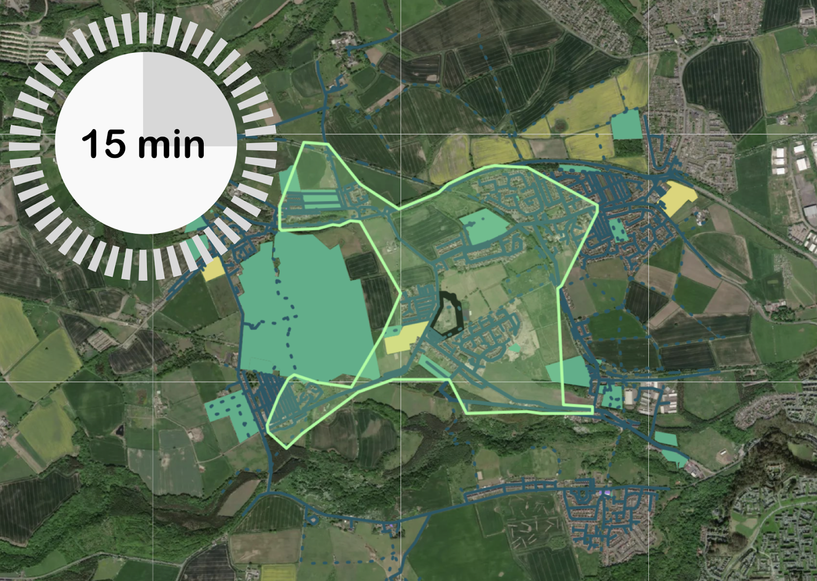
The extended neighbourhood (15-minute walk)
The 15 minute walking distance covers the extended neighbourhood. This scale is only in control of master developers, who masterplan town-scale developments. Mapping of local facilities is essential to understand capacity, determine potential intervention; and build suitable destinations for active travel in the neighbourhood. Most people are prepared to take those walks for a brief shop or to visit a local store or pub. Here we find that some key destinations are within reach, including a grocery store, outdoor sports facilities, and a primary school. However, post offices, cafes, or GPs are few and far between, providing fewer reasons for walking.
The nearby town or city (30-minute walk)
The 30 minute distance could be to the next town or city, in this case Chester-le-Street. Connections between the local cycling and walking tracks are key to supporting longer distance walks. In rural areas the tracks can be uneven, disconnected or involve hilly terrain. This distance is in the remit of transport plans by local authorities.
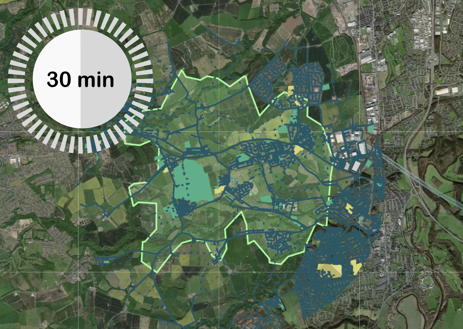

Looking at the benchmarked travel statistics we can see that cycling is substantially lower than the national average, which suggests that it is not part of the everyday life of local citizens. Public transport near the site can compensate, but some part of the road infrastructure could be improved for cycling use. Contributions to local transport infrastructure and a coordinated review of local corridors can aid active travel in such communities.
Conclusions
Understanding the connectivity of a site and accessibility of key services that make people walk and cycle regularly (e.g. grocery stores, GPs, open spaces, schools) is key to develop well-informed designs, that plan for the future. Developers who plan quality into their development business cases can reap benefits of a long-term increase in profitability and certainty for their development portfolio.
Easily assess walking access to GPs, schools, open spaces, and more with Site Insights
Schedule an online meeting with our customer success team