
Mapping Progress: Defining Local Impact Areas in Urban Development
Topics
Intro
Increasingly, housing and regeneration organisations like Homes England adopted a place-based regeneration approach, integrating the meticulous definition of local impact areas as a cornerstone of project delivery, underscoring their pivotal role in ensuring targeted, beneficial outcomes for communities, supporting health impact assessments, and outcome monitoring.
For the UK Green Book identifies an approach referred to as Place-Based Analysis: ‘Place Based Analysis concerns appraisal applied to geographically defined areas within the UK. This definition includes a wide range of obvious categories such as villages, towns, cities, counties and regions and the home countries that make up the UK, it also includes other geographically based definitions such as “rural areas” or “areas of urban deprivation.”
In our discussion on the transformative power of investment, we zero in on local impact areas, distinguishing them from the broader concept of topical areas. This distinction emphasises the tangible, geographical regions that directly reap the social value benefits of new developments, highlighting the crucial role of place-based strategies in fostering meaningful, localised enhancements.
Why is the definition of local impact areas useful and important?
The definition of a local impact area is fast becoming a key necessity in the space of social value, health impact reviews, and other appraisals.
It’s important to:
- Clarify and definition: help identify the geographical and social extent to which a project, such as housing development, influences local economies, social structures, and the environment.
- Consideration of benefits: Focused assessment of how a project contributes to or detracts from the welfare of a community or region
- Better link to local government priorities: aligning projects with governmental priorities, such as levelling up and reducing regional disparities
- More community support: Helps to consider local people and their needs and in turn can make projects more supported if it shows that there are direct local benefits for residents.
This approach underlines the importance of place-based analysis, emphasising that the success of a project should be measured not just by its immediate outputs but by its contribution to the long-term well-being and resilience of communities.
What are the different ways to set the local impact area?
Currently, impact areas can be defined in different ways, and there is not necessarily a common single standard. Impact areas can be set based on the design team's expertise, or based on some other formal guidance.
In terms of the review of impacts, the term “impact area” can certainly overlap or be the same as the study area that an architect may take but in practice it may be wider as impacts may be experienced based on travel distances.
Here are several different ways of defining the impact area:
- Official geographies (e.g. district vs county; or wards vs district) — Strength: easy to access official statistics are available; Weakness: administrative boundaries often don’t mirror actual use of space.
- Distances around study area (e.g. 1.5km or 2km distances): Strength — clearer association and nuance; Weakness —Potential lack of official data fitting to those scales.
- Walkable or travel-based distances of site users (e.g. to nearest employment centre): Strength — Captures wider local links beyond admin boundaries; Weakness — May increase scope considerably
- Mixed (applying a mix of scopes for different impacts, e.g. housing vs employment): Strength — Can capture nuances for things that have different impact scope; Weakness: Additional complexity.
For example, Homes England says that “Depending on the number of housing units being developed, the impact area is taken as a 1.5km or 2.5km radius of the scheme, using the centroid of the site.”
(source)How do local impact areas link to a social value agenda?
The concept of local impact areas, as outlined in the provided material, inherently links to a social value agenda by focusing on the geographical regions directly benefiting from investments and development projects.
Social value prioritises the well-being and enhancement of specific communities, ensuring that the socio-economic advancements facilitated by new investments are both intentional and measurable. It underscores the importance of place-based strategies in achieving equitable development, fostering community engagement, and enhancing local environments in a way that aligns with broader social value objectives.
Moreover, by delineating geospatial impact areas, the project team can identify and, to some extent, quantify the tangible benefits accrued to communities, such as improved housing, access to services, and environmental sustainability.
This alignment with a social value agenda highlights a commitment to not only economic growth but also to the improvement of quality of life, social cohesion, and the fostering of resilient communities. It reflects a holistic view of development that integrates economic, social, and environmental considerations, thereby ensuring that investments contribute to the sustainable and inclusive growth of the areas most in need.
How does local impact areas link to health impact reviews?
The focus on geospatial impact areas within development projects directly enhances the effectiveness of health impact reviews by providing a clear, defined geographical scope for analysis.
This geographical specificity allows for a more targeted assessment of how new investments can influence health outcomes within a community, facilitating a deeper understanding of the direct and indirect health benefits or risks associated with development projects.
By identifying and evaluating the health impacts within these defined areas, stakeholders can tailor interventions to address local health needs and disparities, promoting healthier communities through improved access to healthcare services, green spaces, and healthier living conditions.
By explicitly linking geospatial impact areas with health impact reviews, projects can more effectively contribute to the overall well-being of the population, demonstrating relevance to local people, and provide a commitment to the principle that good health is foundational to social value and community prosperity.
How do local impact areas link to transport?
As an aside, the linkage between transport and the definition of local impact areas is particularly well developed for broader planning and assessment processes for significant infrastructure projects.
The concept of Local Impact Reports (LIRs), as highlighted in guidance by the Infrastructure Planning Commission, serves as a pivotal tool in evaluating the comprehensive effects of such projects, including those related to transport.
These reports meticulously detail the potential impacts on local areas, considering factors such as local transport patterns, site and area constraints, and socio-economic aspects, which are essential for a holistic understanding of how transport infrastructure intersects with housing developments.
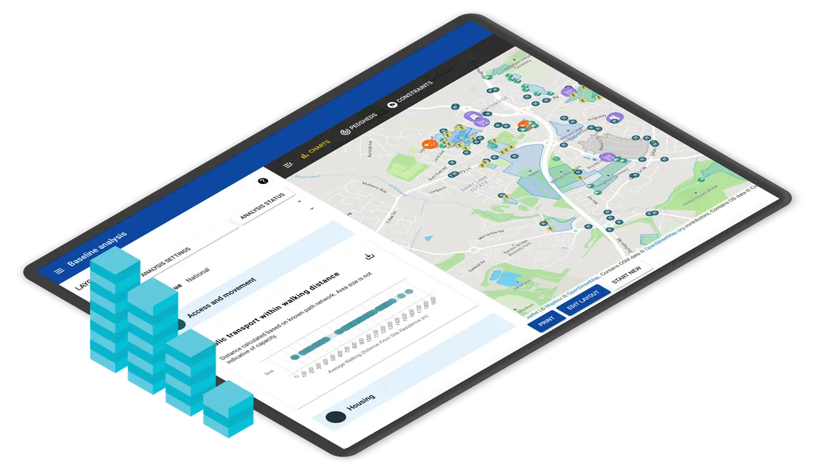
How does PlaceChangers place analytics help set an impact area?
Map-based analytics tools, such PlaceChangers' health/wellbeing focused place analytics tool significantly enhances the process of defining and understanding impact areas for development projects.

By leveraging distance-based scoping, data enrichment and contextualisation, PlaceChangers offers a precise method for delineating the geographical boundaries that will be directly influenced by proposed investments. This approach ensures that the impact area is accurately defined, capturing the specific locales that stand to benefit or be affected by development initiatives.
Furthermore, the platform’s capacity for local data enrichment provides a rich, contextual layer to the analysis. This means that stakeholders can access a wealth of information specific to the area in question, ranging from population characteristics to social infrastructure assets, thus enabling a comprehensive understanding of the local context.
PlaceChangers’ analytics tool empowers users to incorporate a wide array of local data relevant to the impact area, including:
- Population demographics: Insight into age, income levels, and other socio-economic factors.
- Population health: Data on local health outcomes, access to healthcare facilities, and prevalent health concerns.
- Social infrastructure assets: Information on community centres, parks, schools, and other key social infrastructure.
- Housing profile: Details on housing density, types, ownership patterns, and affordability.
This multifaceted approach to defining impact areas not only ensures that projects are accurately targeted but also enriches the decision-making process with a deep understanding of local needs and potential impacts.
Through distance-based scoping and local data enrichment, PlaceChangers’ place analytics tool is instrumental in setting impactful and meaningful development boundaries that are responsive to the specific characteristics of the community and place.
A word on community consultation
When consulting communities on local proposals, having a view on local impacts, and appreciation of how, where, and by whom they will be felt, can make a difference in how supporting community members may be.
Projects that can show local benefits in meaningful ways have a good chance to attract a greater level of buy in from nearby residents.
Wherever possible it helps to add early stage consultations to review area needs, so that prioritise can shape potential development contributions. It is also advisable to clarify and negotiate suitable contributions with the local council which can be locally-relevant and meaningful to avoid large abstraction and quantification of impacts that appear hard to understand.
Conclusions
An impact area, in the context of housing projects and urban development, is a clearly defined geographical zone that experiences direct benefits or transformations due to new investments.
It's a concept that has gained traction among developers and urban planners, especially with the adoption of place-based regeneration strategies by organisations such as Homes England. These areas are not merely administrative boundaries but are identified based on actual, on-the-ground impacts on local communities, economies, and environments.
The focus on impact areas ensures that development projects contribute meaningfully to the welfare and resilience of targeted communities, aligning with broader social value objectives.
Digital tools like PlaceChangers' place analytics play a crucial role in identifying and understanding these impact areas. By utilising distance-based scoping and enriching local data contextual to the area, these tools offer a precise and comprehensive way to delineate the boundaries of impact areas. This not only allows for a more targeted approach to project planning and implementation but also ensures that the socio-economic advancements facilitated by new investments are both intentional and measurable.
Ultimately, the use of digital tools in defining impact areas represents a significant step forward in achieving sustainable, inclusive growth and enhancing the long-term well-being of communities.
Understand community needs and complete impact reviews
Book a demo or start your free trial today.
Start Free TrialGet new articles in your inbox
Subscribe to get more insights like this delivered to your inbox.