Intro
GIS and BIM are both popular technologies for planning in the built environment. While GIS and BIM are independent systems, they can work together to improve efficiency, reduce costs and increase the sustainability of a project over the long term.
Integration of GIS and BIM can be used in architecture and planning throughout the pre-construction phase, which PlaceChangers supports with place analytics and interactive community engagement consultations.
The integrated application of GIS with BIM is cost-effective when implemented correctly and is the future of construction.
For successful integration of GIS with BIM, there must be a collaboration between stakeholders to understand the benefits, beyond 3D visualisation, that such integration can bring for architecture and planning.
GIS and BIM are essential to planning
Planning and construction is a team sport of many different disciplines. It’s the strength of the industry to be dependent on collaboration across long project durations, across vastly different scales, and across stakeholder priorities.
GIS and BIM are the two most popular technologies in the built environment. They have been developed alongside each other over the years.
What is BIM?
BIM stands for Building Information Management, which describes a host of techniques and methods to author buildings.
It also involves a toolset where a 3D model of the building can be generated which holds information about its structure and components. Once created, BIM enables faster design updates to buildings through an integrated design environment. The BIM process allows for better coordination between different teams contributing to a project – architects, engineers and contractors can work seamlessly together using this system because it provides detailed representation.
BIM models allow for more efficient modelling and predictions of building attributes such as energy consumption based on projected usage in different scenarios, materials, and building layout. They can also help reduce waste by making sure all materials used throughout construction processes have been adequately accounted for at each stage, so nothing gets left behind or forgotten about later on down the line after construction has been completed.
What is GIS?
GIS, on the other hand, is an abbreviation for geographic information systems. A GIS allows you to store, share and analyse data that is tied to location. It can be used in many industries such as real estate, agriculture and construction.
At PlaceChangers, spatial analytics to understand health and wellbeing attributes of a place are driven by a GIS, which holds location information and can perform calculations based on the relationship between each.
Integration of GIS and BIM
Integration of GIS and BIM can be useful to architecture and planning throughout the project, including the pre-construction phase. With integrated GIS and BIM, you can improve efficiency, quality, sustainability and environmental impact.
GIS and BIM integration is still challenging.
Many projects fail to take advantage of this technology because the tools and processes are not fully integrated. The most common cause of this failure is that GIS and BIM are used separately rather than together. This can be due to project limitations on budget or time frame or simply because a project team doesn’t understand how these technologies work together.
People and skills
In order for the integration of GIS and BIM to be successful, there must be a collaboration between different stakeholders. The role of each stakeholder is essential, whether they are an architect or engineer, because everybody will have their own set of responsibilities depending on their job title.
For example, an architect might use their skill set with CAD software to create a 3D model that contains information like building geometry and other attributes such as room dimensions or lighting fixtures. This could then be linked up with a plan view of the site using GIS tools, which would allow them to visualise how things fit together before construction takes place.
Tools and data formats
Generally GIS and BIM integration is also hampered by the incompatibility of different toolsets.
For BIM-GIS integration, it is important to devise a long-term data strategy that is as open and compatible as possible. One way to achieve this is through open and free standards. For GIS this could be KML or GeoJSON for instance. For BIM, IFC is emerging as a free and open standard to exchange building information.
Revit file formats are a closed source data format for exchange of building information. While Revit is highly advanced and brings design unique capabilities for architects, it means that all users need to use Revit, an expensive toolset. Instead, it is possible to convert models to open formats, such as IFC, which enable a degree of flexibility in data exchange.
Prioritise use cases for GIS and BIM integration
BIM-GIS integration can come in many forms. You need to determine what your use case is and, based on that, select what preferred approach to take. Some example approaches increasingly used include:
- Google Earth: Google Earth enables placement of building models. This is a desktop tool suitable for basic presentation of models in context.
- VuCity: A game engine based service to generate detailed representations of cities. In London, some councils ask for placement of models in VuCity. It is good for visualisation and analytics.
- PlaceChangers digital planning toolkit: A planning tool set driven by a powerful interactive online mapping engine which can also host BIM models. It is good for high level visualisation, individual buildings, and housing projects which require easy web access.
In some cases, tools can be combined. For example, VuCity provides an interactive viewer which can generate 3D views on the fly for specific locations. Those views can be embedded in a digital platform toolset such as PlaceChangers.

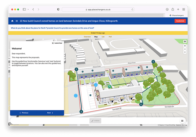
PlaceChangers consultations bring together BIM models and maps for more accurate and productive feedback.
Online platforms enhance the integration of BIM and GIS for planning
This integration of BIM and GIS can be enhanced with the use of online platforms that simplify the integrated use of location and building information for specific use cases, such as collaboration between multiple stakeholders in real-time.
This could be done using an online platform such as PlaceChangers, which provides a powerful mapping engine that can hold a limited set of BIM models.
This could be useful for tasks such as shaping the layout of a building or street network to residents in order to get their feedback before construction begins. A combined BIM and GIS setup enables previewing key buildings in more detail and in the context of an interactive city model.
An online platform which combines GIS and BIM can also enhance community consultation processes. This is especially useful for projects such as planning new roads or buildings, where a number of stakeholders and residents will be affected by the development. An online platform can allow consultees to provide feedback on their neighbourhood in real time via an interactive map. This allows stakeholders to see how their input affects the final design and gives them confidence that their views have been considered by planners.
Online platforms also make technical complexity easy by offloading the need for handling complex IT infrastructure.
Conclusion
It's important to note that there are many benefits of integrating GIS with BIM beyond 3D visualisation.
This includes improved communications between stakeholders and increased productivity, which leads to a more sustainable design process. As the world continues its transition towards a cleaner, more efficient future, it will be critical that we find ways to incorporate technology into our workflows that help us achieve this goal.
Tools such as PlaceChangers, a leader in interactive planning consultations, enable the incorporation of social outcomes in planning and development through interactive consultation and geospatial analytics for health and well-being. PlaceChangers is a leader in terms of integration of open standard BIM models from ifc files to enhance public consultation.
If you like to discuss this further, arrange a demo with one of our experts.
Explore the PlaceChangers planning toolkit

PC Engagement - market leading planning engagement
Set up powerful map surveys and polls based on the changes that may come up on your estate and prioritise future planning interventions more easily.

PC Site Insights - Unique location insights tool for health and wellbeing outcomes
Start to make use of location data and enrich your community engagement planning with insights on local people. Add in your own data sources and gather analytics in one place.
