In town planning and property development, the significance of data analytics cannot be overstated. With urbanisation on the rise and cities becoming more complex, data analytics has emerged as a critical tool for informed decision-making and efficient project execution.
By harnessing the power of data, town planners and property developers can gain valuable insights into demographic trends, infrastructure needs, market demand, and environmental considerations. These insights enable stakeholders to devise well-informed strategies, optimise resource allocation, and create sustainable and resilient urban spaces that cater to the evolving needs of communities.
In this context, data analytics serves as the compass guiding the trajectory of modern urban development, enhancing its effectiveness and fostering innovation in the pursuit of functional and harmonious living environments.
What is place analytics?
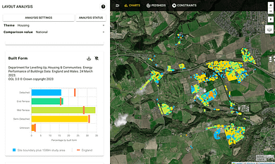
We define place analytics as the use of automatic geospatial analytic checks against key datasets available on a place - with the intent to understand aspects that can affect and shape designs or related to local people and local assets. Such place-based analytics can be done on various topics, including residents, health care services, school capacities, and open space access. Place analytics typically focus on the area around a project site.
Place analytics can be used to support quick investigations at project inception based on data readily available on a place, local assets, and people. It can include data sources such as Census data, data on local social infrastructure such as schools and health care, or presence of other local features, such as shops. Place analytics can also come in when generating a birds eye perspective of the characteristics of architecture and the built environment in a particular area.
The early analysis will need to understand the place to unlock positive opportunities from investments and interventions. This is where awareness of spatial relations can be powerful. The more detail on a place can be understood using a geospatial dimension, the better for later project delivery.
What options are available for map analysis in town planning?
Early stage analysis of places is typically part of the regular desk study and investigation into an area. Complementing other parts of investigation, including site visits, place analytics can be used to develop a quick picture on an area, its people, and local assets.
There are a range of options to gain those insights. Geospatial analytics in early stage site investigations used to be the preserve of experts, but with advancement of online map tools, place analytics can now be done by anybody.
Here we compare the place analytics capabilities built into PlaceChangers, a leading digital planning tool, with some of the more traditional tools for analysis of geospatial dataset.

Strength
- Automatic analytics for planning applications, public consultation, brief development, and health impact statements
- Automatically configured data sources for constraints and impact analysis
- Automatic national & regional benchmarks to understand place differences
- Usable even without GIS background
Training needs
Low
Cost
Starting at £200/per project or £600 per user per year

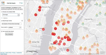
Strengths
- Customisations and range of analysis tools
- Manual setup and use
- General purpose map use and production
- Detailed, later stage geospatial analysis
Training needs
Medium / high
Cost
Starting at £766 per user per year

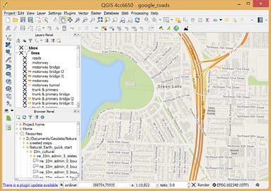
Strengths
- Free to use general purpose desktop-based GIS tool
- Wide range of plug ins to expand analysis capabilities
- Bespoke geospatial analysis
- Good for in-house GIS experts or individual use
Training needs
High
Cost
Free
Why use a map analysis tool such as PlaceChangers for town planning projects?
Place analytics tools, such as on PlaceChangers, are built to provide a user-friendly interface specifically tailored to the needs of urban planners and property developers, who do not see geospatial analytics as the central part of their job and, instead, want to benefit from an easy interface to undertake quick due diligence or use insights on a place to prepare planning applications.
Modern map analysis tools for place-based data allow professionals to quickly access and interpret spatial data without the steep learning curve associated with comprehensive GIS platforms like ArcGIS. As they are developed for use in town planning, analytics tools such as on PlaceChangers, include targeted features and visualisations that directly align with the analytical requirements of these roles, facilitating quicker decision-making and efficient project management.
Bespoke place analytics tools can sit alongside traditional GIS tools, for example, to scale quick analytics capabilities to a wider range of users within an organisation. Analytics tools can often tap into other map data, for example hosted in ArcGIS servers, so to ensure compatibility.
Conclusion
Many tasks in preparing planning applications benefit from quick geospatial insights based on available, validated datasets on local people, assets, and housing.
Easy-to-use place analytics, such as in PlaceChangers, lets town planners tap the power of geospatial insights without the large and extensive training need associated with. These online tools are often better suited for town planners' needs as they have been designed for specific use cases.
In contrast, tools such as ArcGIS Online are general-purpose analysis tools, which are powerful but difficult to learn. As a general purpose tool, GIS software is designed for data analysis tasks involving GIS experts, and therefore are better for GIS technicians rather town planners or developers.
Place analytics such as on PlaceChangers is focused on understanding all attributes of a place, especially for design briefs and impact analysis, which can be later combined with other capabilities relevant to town planners, such as community consultations and appraisals.
Explore the PlaceChangers planning toolkit

PC Engagement - market leading planning engagement
Set up powerful map surveys and polls based on the changes that may come up on your estate and prioritise future planning interventions more easily.

PC Site Insights - Location insights for town planning
Start to make use of location data and enrich your community engagement planning with insights on local people. Add in your own data sources and gather analytics in one place.
